UPDATE: March 17, 11:05pm
NWS has given all of Middle Tennessee the “all clear” update for severe storms and tornadoes Wednesday night.
“We no longer expect any severe weather in our coverage area. There will continue to be a risk for heavy rainfall and local flooding, and a few advisories or warnings may be issued for flooding,” NWS writes on Facebook.
UPDATE: March 17, 1:26pm
The National Weather Service predicts the severe weather will hit our area between 8pm and midnight Wednesday night.

UPDATE: March 17, 9:49am:
The NWS posted an update on Wednesday’s storms:
- Storms are already underway to our southwest.
- The storms will continue to lift north Wednesday morning and afternoon and could contain a strong or isolated severe storm.
- The main severe threat is later tonight, most likely around or after sunset through 3 or 4am Thursday morning.
- During this timeframe we could see straight-line damaging winds, hail, and tornadoes.
- These storms could also contain heavy rain, and could cause isolated flooding issues.
- The worst of this system will be moving through after dark, so have a severe weather plan in place for tonight

Original Story:
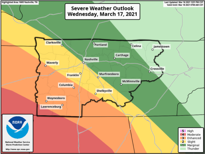
Severe weather is expected in the middle Tennessee area Wednesday, March 17th.
The National Weather Service (NWS) has outlined its predictions on when and where the storms will occur.
Severe weather is expected in the afternoon, continuing into the night and until 2am Thursday.
Look at the map below from NWS to assess when your area will be affected.

How Bad Will the Storms Be?
As explained by NWS:
“The position of the warm front will have the greatest impact on the environment Wednesday afternoon and evening. Models want to bring the warm front into the area oriented along I-24 (with the warmest and most unstable air south and west of I-24 in the Slight/Enhanced/Marginal Risk areas) Wednesday afternoon. But, if that front moves further north and east, the severe threat will spread north and east with it.
Damaging wind gusts remain the primary threat with any severe thunderstorms that develop, but large hail, flooding, and a few tornadoes will all be possible.

Detailed Forecast Through Thursday:
Partly sunny, with a high near 75. West southwest wind around 5 mph.
Mostly cloudy, with a low around 54. Calm wind becoming east southeast around 5 mph after midnight.
Showers and thunderstorms. High near 72. Southeast wind 5 to 15 mph, with gusts as high as 25 mph. Chance of precipitation is 90%. New rainfall amounts between a quarter and half of an inch possible.
Showers and thunderstorms, mainly before 5am. Low around 56. South wind 10 to 15 mph, with gusts as high as 25 mph. Chance of precipitation is 90%.
A chance of showers and thunderstorms before 7am, then a slight chance of showers between 7am and noon, then a chance of showers and thunderstorms after noon. Mostly cloudy, with a high near 61. Southwest wind 10 to 15 mph, with gusts as high as 25 mph. Chance of precipitation is 40%.


