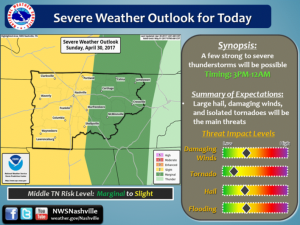
 Ok, it’s been a busy Spring for severe weather, and today is proving to be another challenging day. The only 2 things we do know for sure are that it’s going to be windy all day and it’s going to rain. Rain hard on already saturated grounds.
For LIVE RADAR with storm tracker Click Here
This morning will be relatively calm, but windy. Wind gusts of 45 mph are expected today. Heavy rains move in later on this afternoon and evening , localized flooding is expected. Large hail and tornadoes are a possibility also
Official Statements for Wind advisory and Severe Weather from the NWS are as follows:
WIND ADVISORY IN EFFECT LATE THIS MORNING INTO THIS EVENING...

* TIMING...10 AM through 10 PM.

* WINDS...sustained breezy winds of 15 to 25 mph...with gusts of
  40 to 45 mph possible.

* IMPACTS...Wind gusts could bring down tree limbs and cause of
  few power outages, as well as shallow rooted and infirm trees,
  may be blown down. Loose outdoor objects, like garage cans,
  patio furniture, and unanchored soccer goals will be blown
  over.

PRECAUTIONARY/PREPAREDNESS ACTIONS...

A Wind Advisory means that winds over 40 mph are expected. Winds
this strong may blow down a few trees or tree limbs and cause
isolated power outages. Driving may also become difficult...
especially for high profile vehicles. Use extra caution.
DAY ONE...Today and Tonight
Widespread thunderstorms are expected to move across middle
Tennessee this afternoon and evening. Some storms may be strong to
severe...with damaging winds...hail...and a possible tornado...especially
west of interstate 65. Storms could also contain heavy
rainfall...especially across southern middle Tennessee with the
additional threat of isolated flash flooding.

In addition to thunderstorms, the front will bring strong gusty
winds. A wind advisory is valid for locations outside of the
plateau from 10 am until 10 pm. Winds gusts to 40 mph will be
possible.


.DAYS TWO THROUGH SEVEN...Monday through Saturday
No hazardous weather expected at this time.

.SPOTTER INFORMATION STATEMENT...
Spotter activation may be needed this afternoon and tonight.


$$
Spotter Thunderstorm Reporting Criteria
Tornado
Funnel Cloud
Flooding
Hail >= 1/2 inch
Winds > 50 MPH (Measured)
Structural Damage
Trees or Power Lines Down


