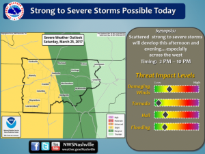
 Round one ,of two strong to severe weather threats in the next 72 hours , is due to hit after noon today. Enjoyably warm temps will allow those who want to do some early morning gardening to be able to do so. Anytime from about the noon hour on, things could get dicey. With warm and juicy air already in place this morning, pop ups could develop in front of the line. Will it all get out in time for an enjoyable evening? I wouldn’t hold my breath. Check our radar to help you with plans. We will be posting on Facebook and Twitter any watches or warnings should they be issued. Today’s main threats will be straight line winds and heavy rains, however, hail is not out of the realm possibility.
The official statement from the NWS is as follows:
505 AM CDT Sat Mar 25 2017

This Hazardous Weather Outlook is for portions of Middle
Tennessee.

.DAY ONE...Today and Tonight

Strong to severe thunderstorms will be possible this afternoon and
evening especially west of I-65. Damaging straight line winds,
hail, and heavy rain will be the main threat, however a brief
tornado cannot be ruled out. The main timeframe for stronger
activity will be from 2pm to 10pm.

.DAYS TWO THROUGH SEVEN...Sunday through Friday

Strong to severe storms will be possible again on Monday for areas
west of I-65. Damaging straight line winds and hail will be
the main threats.


