UPDATE: March 28, 12:34am
Flash Flood Warning continues for La Vergne TN, Lebanon TN, Mount Juliet TN until 4:00 AM CDT pic.twitter.com/IlA5EIoumj
— NWS Nashville (@NWSNashville) March 28, 2021
UPDATE: March 27, 11:53pm
NWS has issued a Severe Thunderstorm Warning for:
Southern Davidson County
Northwestern Rutherford County
Northeastern Williamson County
West central Wilson County
Until 12:15 AM
UPDATE: March 27, 10:22pm
Flash Flood Warning including La Vergne TN, Lebanon TN, Mount Juliet TN until 4:00 AM CDT pic.twitter.com/XOKZq3P7y5
— NWS Nashville (@NWSNashville) March 28, 2021
UPDATE: March 27, 9:20pm
Still looks Flashy McFloody with a wall of heavy rainfall yet to cruise through. Tornado worries very low/near zero, but still have a few severe storms out west. Avoid driving in this stuff / 904 PM. pic.twitter.com/s4FnJCiiV5
— NashSevereWx (@NashSevereWx) March 28, 2021
Stay Weather Aware: Live Weather Radar
UPDATE: March 27, 8pm
Get the latest from NWS on what to expect overnight:
UPDATE: March 27, 7:36pm
Flash Flood Warning including Murfreesboro TN, Woodbury TN, Unionville TN until 10:45 PM CDT pic.twitter.com/jYiA6CHt4D
— NWS Nashville (@NWSNashville) March 28, 2021
UPDATE: March 27, 7:27pm
Severe Thunderstorm Warning continues for Murfreesboro TN, Unionville TN, Eagleville TN until 7:45 PM CDT pic.twitter.com/LSgoAAcOUf
— NWS Nashville (@NWSNashville) March 28, 2021
UPDATE: March 27, 7:05pm
Severe Thunderstorm Warning including Murfreesboro TN, Thompson’s Station TN, Chapel Hill TN until 7:45 PM CDT pic.twitter.com/53NC7ASUJz
— NWS Nashville (@NWSNashville) March 27, 2021
UPDATE: March 27, 3:00pm
Flooding remains a major concern:
NashSevereWx reports: “Already 2″ to 3″ has fallen, much more incoming. Main concern for the worst flooding is south of I-40, and especially cutting through Will Co. Nashville will see less rain by comparison, but it also doesn’t drain as efficiently. Concern rising for flash flooding tonight.”
A Flash Flood Watch remains in effect until 7 AM Sunday.
More Storms Expected This Evening
Timing for the most intense storms is roughly 9PM-2AM. This could change with newer data, per NashSevereWx
Tornado Watch South of Rutherford County
NWS issued a Tornado Watch until 9pm for parts of Alabama, Arkansas, Mississippi and Tennessee until 9 PM; however, NWS says if you live north of the watch this does not mean you are in the clear. Keep monitoring because we may need to include you in an additional watch later this evening. The threat may struggle to reach as far north as Clarksville, but we still can’t rule out a severe weather threat that far north later tonight.

UPDATE: March 27, 12:30pm
NWS has issued a Flash Flood Warning for the following until 3:15pm:
Northwestern Bedford County
Northeastern Marshall County
Southeastern Maury County
Southwestern Rutherford County
Southeastern Williamson County
A Flash Flood Warning means that flooding is imminent or occurring. If you are in the warned area move to higher ground immediately. Residents living along streams and creeks should take immediate precautions to protect life and property.
A Flash Flood Watch remains in effect until 7 AM Sunday.
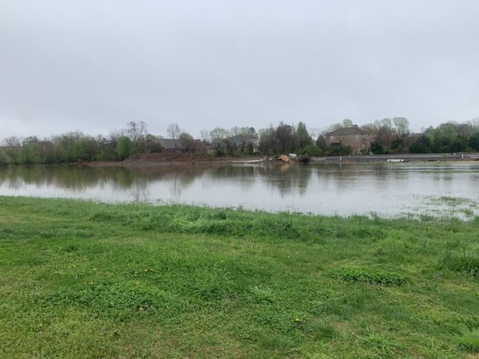
Flooding is a major concern across middle Tennessee for Saturday.
The heaviest rain hasn’t even arrived yet. If the rivers and creeks in your location already look like this, be prepared for them to get even worse later today and tonight. Many rivers are likely to overflow their banks. https://t.co/51ixp6QHsz
— NWS Nashville (@NWSNashville) March 27, 2021
UPDATE: March 27, 9:30am
NashSevereWX reports all the warnings are over for this morning. More rain incoming. Another round of storms possible this afternoon, and/or likely tonight.
A Flash Flood Watch remains in effect until 7 AM Sunday.
Most favorable tornado conditions late tonight maybe-might-possibly develop juuuuust south of us per 12z HRRR model run. Or they may bisect or cover Davidson & Will Co. Draw no conclusions – thin margins, model err possible. Stay connected, forecast will need revisions/updates. pic.twitter.com/ZemU1GE5tt
— NashSevereWx (@NashSevereWx) March 27, 2021
UPDATE: March 27, 8am
Multiple rounds of storms are expected on Saturday. The first round is moving across middle Tennessee this morning with a torrential downpour, hail, thunder and lightning.
Severe Thunderstorm Warning including Franklin TN, Smyrna TN, La Vergne TN in effect until 8:45 AM CDT
Rain is expected to dissipate by later afternoon to early evening. Another round of storms is expected tonight, with the worst of these evening storms most likely will occur between 10 PM and 2 AM, says NashSevereWx.
Biggest threats (from NWS): heavy rainfall leading to flash flooding, so if you live in a flood prone area keep this in mind! Also remember that if you encounter flooded roads – Turn Around, Don’t Drown! However, these storms will also pose a risk for a few tornadoes, thunderstorm wind gusts up to 75 mph, and large hail. Know where your safe place and shelter is located in case a warning is issued for your home today or tonight!

UPDATE: March 27, 7:48pm
Severe Thunderstorm Warning continues for Lebanon TN, Walterhill TN, Gladeville TN until 8:00 AM CDT pic.twitter.com/IXWmfrNg5M
— NWS Nashville (@NWSNashville) March 27, 2021
UPDATE: March 27, 7:30am
Severe Thunderstorm Warning including Smyrna TN, La Vergne TN, Lebanon TN until 8:00 AM CDT pic.twitter.com/9CaWkcJVHg
— NWS Nashville (@NWSNashville) March 27, 2021
Original Story:
Several rounds of showers and thunderstorms are expected across Middle Tennessee from mid-morning hours on Saturday through at least Sunday morning. Above is a graphic of where NWS thinks the majority of severe weather will be focused.
What to Know:
- Flash Flood Watch in effect from 7am Saturday Until 7pm Sunday
- Storm will come in two waves – the first in the morning, then there will be a brief break and then another Saturday afternoon through Sunday morning
- These storms are predicted to be strong to severe, bringing an additional 1 to 3 inches with locally higher amounts ranging from 4 to 5 inches of rainfall to already saturated ground conditions.
- While severe hail/wind is possible in the morning, the greater severe risk arrives Saturday afternoon overnight into Sunday. Tornadoes, large hail, and damaging wind all possible.


