UPDATE: May 4, 9:30pm
NWS reports the chance for severe weather over middle TN are rapidly decreasing. Northwest middle TN (north/west of I-40/I1-65) has the best chance for strong to severe weather through 10 pm. The threat will continue to decrease through the night with little to no chances overnight.
UPDATE: May 4, 3pm
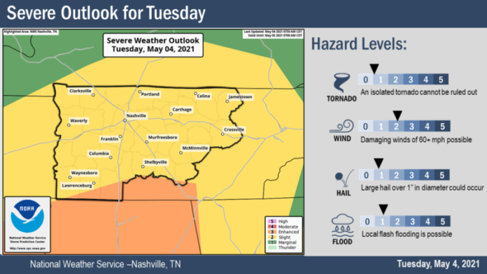
National Weather Service (NWS) predicts the timing of the second round of storms on Tuesday will be 5pm – 1am.
More storm information from NWS:
- Severe thunderstorms are possible generally along and west of I-65 tonight with
strong storms possible east.
• Biggest threat is straight line damaging winds but cannot rule out an isolated
tornado or two and large hail.
• Cold front will move through around 10PM with the severe threat ending at that
time.
• The remainder of the period looks somewhat unsettled with shower chances on
Thursday and again over the weekend.

UPDATE: May 4, 2pm
National Weather Service (NWS) predicts the timing of the second round of storms on Tuesday will be 5pm – 1am.
What to Know:
information provided by NWS
- The storms have the potential of becoming prolific damaging wind producers
causing widespread tree damage and power outages. - Hail larger than golf balls could cause roof and car damage.
- In addition, scattered tornadoes will be possible along with frequent cloud to ground lightning.
- Outdoor events may need additional lead time to enact safety procedures due to fast storm motions and significant impacts.
- Areas Impacted: All of Middle TN. Highest threat will be north of I-40 and west of I-65
but severe parameters look favorable for the entire area. - Confidence is high in the potential for storms to be able to produce
significant winds and hail. Forecast confidence in timing is average. Confidence in
exact locations that will be impacted is below average. - Models are still inconsistent in the placement of storms during
the evening hours. Not everyone will experience the storms but the locations that are
affected could see significant impacts.
UPDATE: May 4, 10:30am
Updated Forecast Discussion from NWS:
Our early morning round of severe weather now over, but another round of severe storms still in the picture for the afternoon and early evening.
A surface low will move just to our northwest later today, and eventually drag a cold front across the mid-state this evening. Showers/Storms are likely to refire by mid afternoon and
continue into the evening as the front passes. Parameters still looking better across the south, but instability does drop off a bit later in the day. At this point, severe storms most likely isolated.
Original Story – 6:30am
A severe thunderstorm watch is in effect until 11am for several parts of middle Tennessee, including Rutherford County and several areas have been under tornado warnings throughout Tuesday morning.
At 623 AM CDT, Doppler radar was tracking strong thunderstorms along a line extending from near Bellevue to near Mount Pleasant. Movement was east at 40 mph.
Pea size hail and winds in excess of 40 mph will be possible with these storms.
Locations impacted include:
Murfreesboro, Franklin, Columbia, Smyrna, Brentwood, La Vergne, Spring Hill, Nolensville, Forest Hills, Mount Pleasant, Oak Hill, Belle Meade, Thompson’s Station, Walterhill, Bellevue, Antioch, Rural Hill, Chapel Hill, Eagleville and Gordonsburg.
This includes the following highways:
Interstate 40 between mile markers 194 and 198.
Interstate 65 between mile markers 40 and 79.
Interstate 24 between mile markers 55 and 77.
Interstate 840 between mile markers 11 and 69.
PRECAUTIONARY/PREPAREDNESS ACTIONS
Torrential rainfall is also occurring with these storms, and may lead to localized flooding. Do not drive your vehicle through flooded roadways.
Second round of showers and thunderstorms will begin to move into the southern counties by the afternoon with an additional line moving into our northwestern counties by the early evening.
Will have some time to destabilize even further this afternoon. Best chance of severe weather does appear to be across our southern counties, with damaging winds and small hail as the primary concerns. Still can’t rule out an isolated tornado as there will still be some low-level turning.
Any lingering showers/thunderstorms will be pushed out of the area as the surface frontal system passes through Wednesday AM. Upperlevel trough will swing through and push eastward the second half of the week with a weak disturbance possible Thursday. Any
showers we do see would be widely scattered. Things will dry out on Friday with dry conditions through the first half of Saturday.
Expect for temps on the cooler side on Thursday and Friday with highs in the mid to upper 60s across the area. The weekend through at least the first half of next week looks fairly unsettled as several rounds of showers and thunderstorms appear possible. Expect
highs to reach back into the upper 70s to near 80 as well.
FORECAST SUMMARY FROM NWS
• A line of showers and strong to severe thunderstorms will move across Middle
Tennessee early Tuesday morning, with damaging winds and large hail possible
• Another wave of showers and some strong to severe storms is possible Tuesday
afternoon into Tuesday evening, with damaging winds and large hail possible
• Rain ends Wednesday morning, with cooler temperatures and low rain chances
the rest of the week through the weekend
• Warmer weather and higher rain chances return early next week


